About the Project
Newport’s city center needs help. Many storefronts are vacant, and buildings are aging or in poor condition. Plus, summer traffic on US 101 and US 20 makes it challenging for locals and visitors alike to enjoy the area to its fullest potential. There is also an increasing need to add more affordable housing in the area.
Through this project, the City of Newport developed a plan to create a vibrant, welcoming city center—home to a diverse mix of successful businesses, housing options and amenities for residents and visitors.
Changes to traffic patterns and new transportation facilities (such as additional bus stops or bike lanes) are key to encouraging redevelopment. In 2022, the City of Newport worked with the Oregon Department of Transportation (ODOT) to develop a new Transportation System Plan (TSP) which began this process. The Newport TSP outlined two route options for Highway 101 through the city center. With the help of the public and others interested in the area through this project, the City chose the one-way short couplet for Highway 101 to best support new development in the project area.
In June and July 2025 the Newport Planning Commission held a work sessiona nd public heard to consider the proposed amendments and voted in favor of the changes. In August and September 2025 Newport City Council held a work session and two public hears to consider the amendments and voted in favor of the changes.
Project Resources
- Newport City Center Revitalization Plan - Final Plan (09/12/25)
- Ordinance No. 2025-04 - Comprehensive Plan Amendments Relating to the City Center Revitalization Plan (09/03/25)
- Citizen Advisory Committee Meeting Materials
- Comment Card (Fall 2024)
- Postcard (Fall 2024)
- Project Factsheet (Fall 2024)
- Project Flyer (Summer 2024)
- Transportation System Plan (2022)
- Memos (2025)
- #1 Policies and Goals
- #2 Existing Conditions
- #3 Market Analysis
- #4 Gap Analysis
- #5 Comprehensive Plan and Development Code Amendments
- #6 Public Investments
- #7 Incentives and Public-Private Partnerships
- #8 Multimodal Mobility Impact Assessment
- #9 Form Based Code and Development/Design Standards (Part 1 and Part 2)
Project Area
The focus of this planning effort was three blocks on either side of US 20 and US 101 (from the east entrance to the City, west to the US 20/US 101 intersection, and then south to the Yaquina Bay Bridge).
This Project identified the one-way short couplet as the option to best support the project objectives. This decision was made based on feedback collected from community members during the fall 2024 survey, public workshop, and focus groups.
One-way short couplet – Between SW Abbey Street and SW 2nd Street, people traveling south on 101 would use the existing highway, which would have two travel lanes for vehicles. Removing northbound traffic from this section of Highway 101 would allow this corridor to have wider sidewalks with landscaping, buffered bike lanes, and on-street parking. Travelers heading north on Highway 101 would use an improved SW 9th Street that would include two travel lanes for vehicles with wider sidewalks with landscaping and a buffered bike lane.
To further encourage growth in the city center, the City is also updating its Comprehensive Plan and development code, and identifying potential public investments and incentives to encourage desired development and livability. Care will be taken to ensure that there is a enduring and vibrant location for the farmers market, and other spaces for public gatherings, art and landscaping. We will work with local businesses, landowners, residents and others in the community to plan for ways to reinvest in the area, now and into the future.
Project Timeline
The revitalization project started in spring of 2024 and should finish in August 2025.
During that time, the City held six Community Advisory Committee (CAC) meetings to provide input on the project and recommendations to City Council on actions to reach the vision for the city center.
The project team also interviewed neighbors, businesses, and other people and organizations to better understand the needs of the community and brainstorm potential solutions. The team held two public events (in-person and online) to share updates on the project and collect community feedback which helped the team and the CAC chose which policies, incentives and highway alignment option to recommend to the City’s planning commission and City Council.
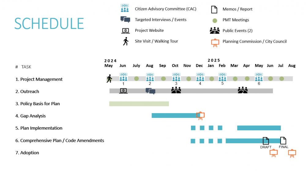
Click to enlarge.
Community Engagement
Public Event 1
The project team held a series of outreach events from November 14 - November 15, 2024. Activities included a community workshop and a community focus group, as well as online options to provide the team with feedback.
Community Workshop Display Boards
Public Event 2
The project team held a series of outreach events from April 1 to April 13, 2025 to share the potential solutions for creating a more vibrant city center. An online open house and survey also collected feedback from community members in English and Spanish.
Community Workshop Display Boards
Citizen Advisory Committee (CAC) meetings
More information about this committee, as well as meeting materials, can be found here.
Comments or questions?
Contact the City of Newport's Community Development and Planning Department for more information.
Acerca del Proyecto
El centro de la ciudad de Newport necesita ayuda. Muchas vidrieras están vacantes, y los edificios están envejeciendo o están en mala condición. Además, el tráfico del verano en US 101 y US 20 le dificultan a los locales y visitantes de la misma manera el disfrute del área en su mayor potencial. Hay también una necesidad creciente para añadir más viviendas asequibles en el área.
A través de este proyecto, la Ciudad de Newport quiere crear un centro de la ciudad vibrante y acogedor – que alberga a una diversa mezcla de negocios exitosos, opciones de vivienda y comodidades para residentes y visitantes.
Cambios en los patrones de tráfico y nuevas instalaciones de transporte (tales cómo paradas de buses o líneas de bicicleta adicionales) serán claves para incentivar la remodelación. En 2022, la Ciudad de Newport trabajó con el Departamento de Transporte de Oregon (ODOT, siglas en inglés) para desarrollar un nuevo Plan de Sistema de Transporte (TSP, siglas en inglés).
El TSP de Newport delineó dos opciones de rutas para Highway 101 a través del centro de la cuidad. Con la ayuda del público y otros interesados en el área, la Ciudad escogerá cual opción para Highway 101 apoyará mejor el nuevo desarrollo en el área de proyecto.
Área de Proyecto
El enfoque de este esfuerzo de planificación será dentro de los 2-3 cuadras del US 20 y US 101 (desde la entrada este a la Ciudad, oeste a la intersección de US 20/US 101, y luego sur al Puente de Yaquina Bay).
En 2022, la Ciudad completó un Plan de Sistema de Transporte (TSP, siglas en inglés) que identificó dos opciones para mejorar US 101 dentro del área del proyecto para promover desarrollo económico y proporcionar la infraestructura para apoyar nuevas viviendas.
Las dos opciones son las siguientes:
- Coplas cortas de Una-vía – Entre SW Abbey Street y SW 2nd Street, gente viajando al sur en 101 usarían la carretera existente, el cual tendría dos líneas de viaje para los vehículos. Remover el tráfico con dirección al norte de esta sección de Highway 101 le permitirá a este corredor tener aceras más anchas con paisaje, líneas de bicicleta amortiguados, y estacionamiento en-la-calle. Los viajantes que van hacia el norte en Highway 101 usarían un SW 9th Street mejorado que incluiría dos líneas de viaje para vehículos con aceras más anchas con paisaje y líneas de bicicletas amortiguadas.
- Dos-vías mejoradas – Dentro de los existentes 74-pies de prioridad-de-paso en Highway 101, las aceras pueden ser ampliadas y el paisaje añadido si el estacionamiento en-la-calle fuera removido. Esto también permitiría cuatro líneas de viaje de 11-pies (el cual es un pie más ancho que ahora). Una vía de bicicletas sería añadida a SW 9th Avenue entre SW Abbey Street y SW 2nd Street en lugar de las líneas de bicicleta en esta sección de Highway 101. La vía de bicicleta de SW 9th Avenue requeriría la remoción del estacionamiento en-la-calle y reducirá el ancho de la línea para vehículos.
Este Proyecto de Planificación de Revitalización identificará cual, de las opciones, o variaciones de las opciones apoyarán mejor a los objetivos del proyecto.
Para incentivar más el crecimiento en el centro de la ciudad, la Ciudad está también actualizando su Plan Comprensivo y código de desarrollo, e identificando potenciales inversiones públicas e incentivos para motivar desarrollos y habitabilidad deseados. Será tomado con cuidado para asegurarse que hay una ubicación duradera y vibrante para los mercados de granja, y otros espacios para encuentros públicos, arte y paisaje. Trabajaremos con los negocios locales, dueños de tierras, residentes y otros en la comunidad para planear por maneras de reinvertir en el área, ahora y en el futuro. La nueva isla media provee beneficios de seguridad y posibles oportunidades para la plantación de árboles.
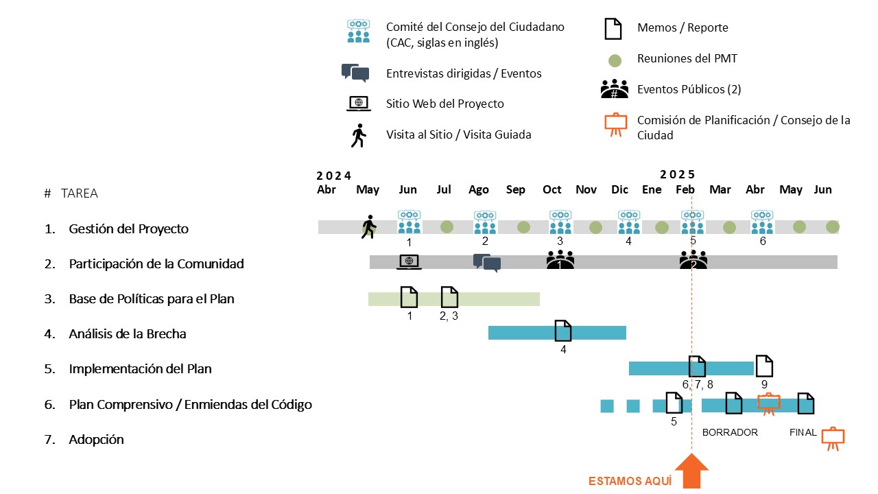
Cronograma del Proyecto
El proyecto de revitalización comenzó en la primavera del 2024 y está programada para cerrar en 2025.
Dentro del curso del siguiente año, la Ciudad llevará a cabo seis reuniones del Comité de Consejo de la Comunidad (CAC, siglas en inglés) para proporcionar comentarios en el proyecto y recomendaciones para el Consejo de la Ciudad acerca de acciones para llegar a la visión del centro de la ciudad.
Este verano/otoño, entrevistaremos a los vecinos, negocios, y otras personas y organizaciones para entender mejor las necesidades de la comunidad y con inteligencia colectiva encontrar potenciales soluciones.
También llevaremos a cabo dos eventos públicos para compartir actualizaciones en el proyecto y darles una oportunidad de proporcionar comentarios.
Estos comentarios ayudarán al equipo y al CAC mientras eligen cuales políticas, incentivos y opciones de alineación de carretera para recomendar a la comisión de planificación de la Ciudad y el Consejo de la Ciudad.
Haga clic en la imagen para ampliar.
Recursos del Proyecto
- Material de la reunión del Comité Consultivo de Ciudadanos
- Tarjeta de comentarios (2024)
- Tarjeta postal (2024)
- Ficha del proyecto (2024)
- Folleto del Proyecto (Verano 2024)
- Plan del Sistema de Transporte 2022
- Memos (2025) (Los memos están disponibles solamente en Inglés. Si necesita ayuda adicional, contáctenos por favor.)
- #1 Policies and Goals
- #2 Existing Conditions
- #3 Market Analysis
- #4 Gap Analysis
- #5 Comprehensive Plan and Development Code Amendments
- #6 Public Investments
- #7 Incentives and Public-Private Partnerships
- #8 Multimodal Mobility Impact Assessment
- #9 Form Based Code and Development/Design Standards (Part 1 and Part 2)
Como involucrarse
Evento Público 1
El equipo del proyecto llevó a cabo una serie de eventos de conexión desde
Noviembre 14 – Noviembre 15, 2024. Las actividades incluyeron un taller comunitario y un grupo de enfoque. Un resumen de estos eventos puede ser encontrado bajo “Recursos de Eventos Pasados”
Evento Público 2
El equipo del proyecto llevó a cabo una serie de eventos de conexión desde
Abril 1 – Abril 13, 2025. Las actividades incluyeron un taller comunitario y un grupo de enfoque. Un resumen de estos eventos puede ser encontrado bajo “Recursos de Eventos Pasados”
Reuniones CAC, siglas en inglés (Comité del Consejo de la Comunidad)
Puede encontrar más información aquí.
Recursos de eventos anteriores
Evento Público 1
Paneles de exposición de los talleres comunitarios
(El resumen del evento está disponible solamente en Inglés. Si necesita ayuda adicional, contáctenos por favo)