Amharc ar an suíomh seo i nGaeilge
Visit the pages on this site using the buttons below, click "Get Started" to move through the information in order, or jump to the survey questions.
= Page includes questions or opportunities for comment.
Image gallery contents:
BusConnects
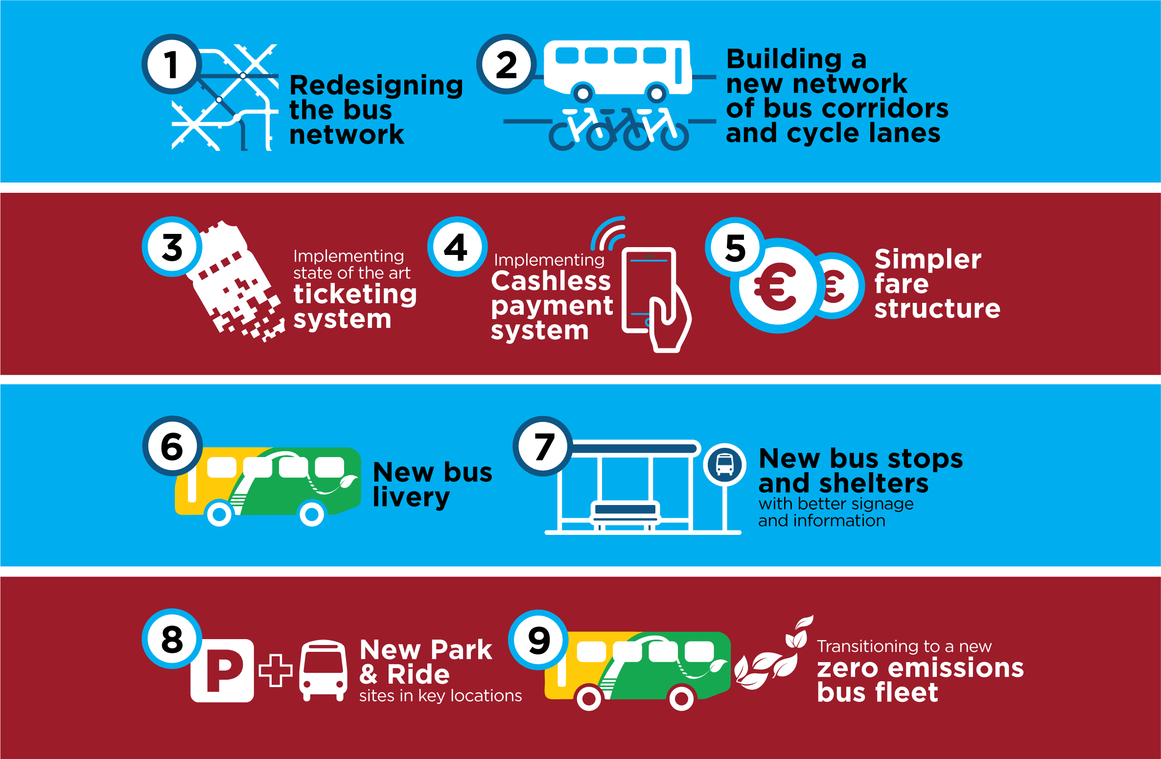
BusConnects will overhaul the current bus system with nine types of improvement and investment. These include: 1. Completely redesigning the bus network. 2. Building a network of new bus and cycle corridors. 3. New state-of-the-art ticketing system. 4. Implementing cashless payment system. 5. Revamping the fare system. 6. New bus livery. 7. New bus stops and shelters with better signage and information. 8. New park and ride sites in key locations. 9.Transitioning to a new zero emissions bus fleet.
2022 Galway urban bus network


Purpose
BusConnects Galway will help realise these local and national policies in Galway City, Bearna and Oranmore:
- The National Development Plan
- The Climate Action Plan
- The Galway Transport Strategy
- The Galway City Council Development Plan
- The Galway County Transport & Planning Strategy
Why are we doing this?
In light of the growth coming to Galway and its environs, and national efforts to reduce carbon emissions from transport, there is an urgent need to re-evaluate and re-invest in bus services in Galway.
The Galway bus network has evolved slowly with the growth of the city. In 2016 the Galway City Transport Strategy identified improvements to the urban bus network which were partially implemented in the years since, but further improvements are due in order to:
- Make public transport more useful and attractive.
- Reduce dependency on the private car.
- Support employment, education and population growth in public-transport-accessible locations.
Bus network redesign
This project is an opportunity to rethink the design of Galway’s bus network, with a focus on today’s needs and imminent growth.
This is a “blank slate” redesign, meaning that proposed revisions include which roads buses run on, times and days of service, frequencies, and where people interchange.
All of the urban bus routes in Galway City, Bearna and Oranmore and its suburbs are under study and may be revised. These routes are currently operated by Bus Éireann and City Direct.
Some proposed routes resemble those in the existing bus network. This is because they would support present and future conditions – not because of history or tradition.
All routes in the Draft New Network have been labelled with new numbers, even if they are similar to an existing route.
The purpose of this online consultation is to invite members of the public to provide their opinion about the future bus network.
Since every detail of the existing network is something somebody relies on, NTA expects a broad range of positive and negative comments. The key question is whether the extent of the proposed improvements outweigh any inconveniences caused by the change itself.
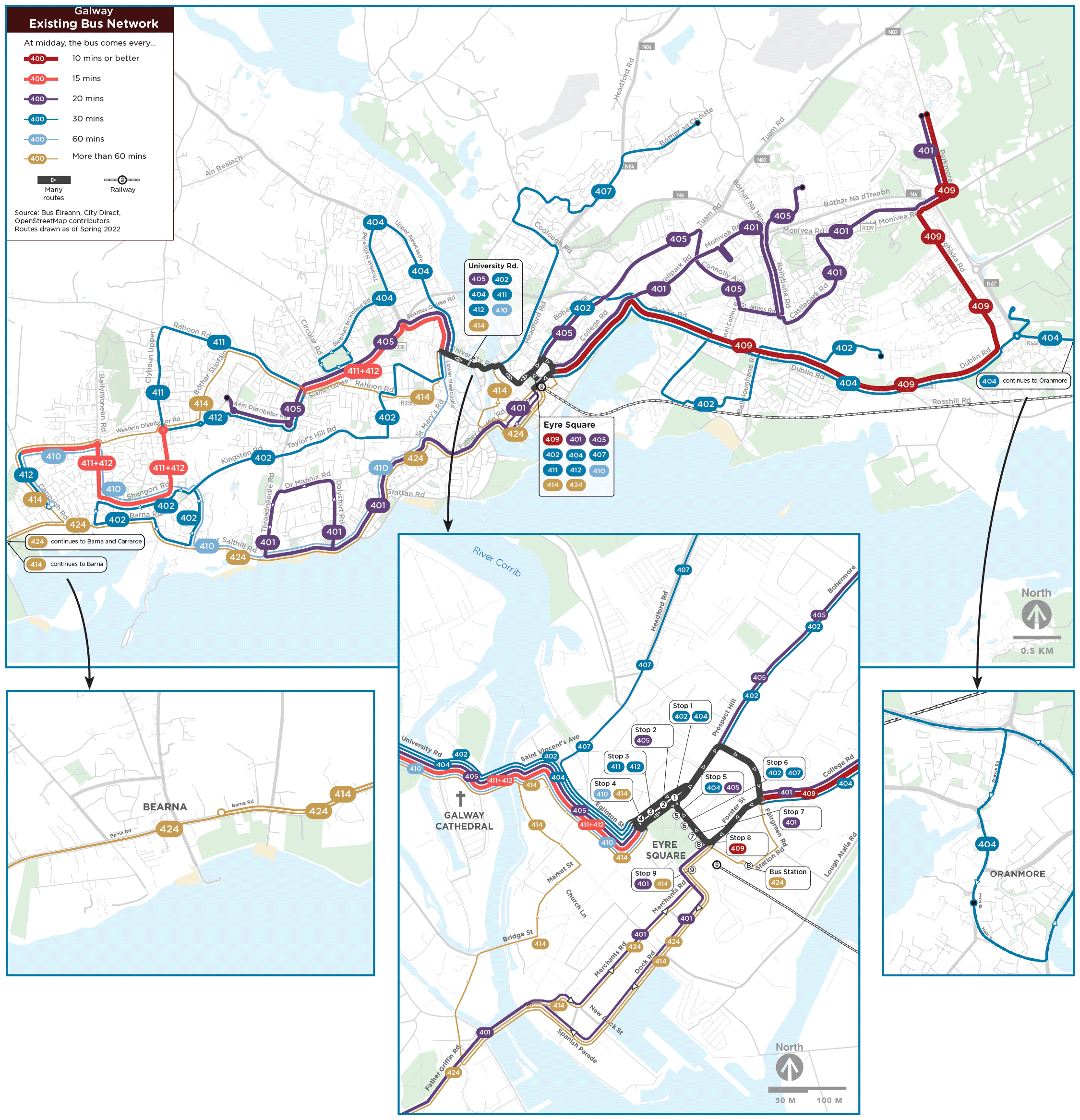
2022 Galway urban bus network.
(Click images to enlarge.)
Read more
- Get more detail on the topics covered here by reading the Draft New Network report (56 MB).
- Visit the BusConnects website at busconnects.ie/galway.
- Read the Galway Transport Strategy.
Review the pages below and learn about key principles in designing an improved bus network in Galway.
Image gallery contents:
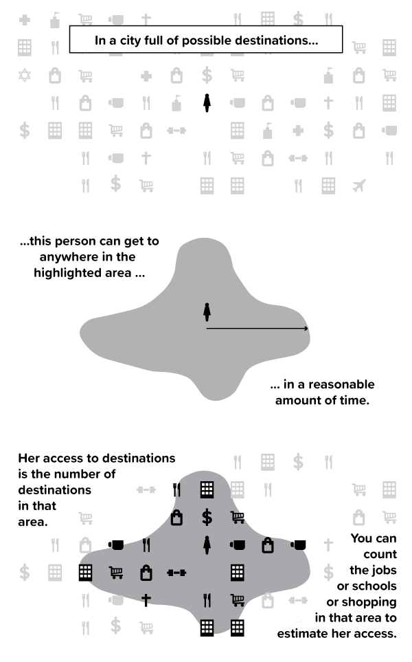
Access
Access is the number of destinations in an area that can be reached in a certain amount of time.
Access
Access is the number of destinations in an area that can be reached in a certain amount of time.
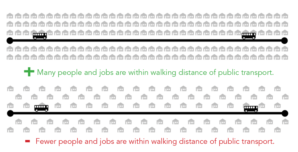
Design for High Access
A public transport network can increase patronage by increasing access. Access describes how many jobs, people, schools, shops, and other opportunities people can reach by public transport, in a reasonable amount of time.
Increasing the average access provided by a network tends to increase patronage because more of people’s trips become possible on public transport without requiring a lot of time.
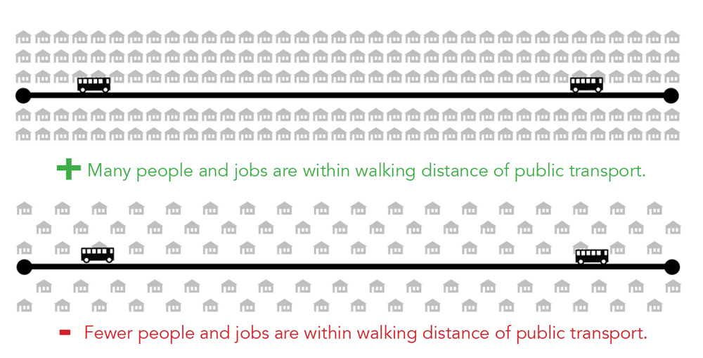
Factors that affect access:
- How many destinations are near public transport routes.
- How long someone walks to and from service.
- How long someone waits for the service.
- How far someone travels on the service.
- The speed of the service.
- How long someone waits to interchange between services.
Public transport authorities have control over some of these factors: waiting time, interchange, route directness, where service is provided.
They have less control or no control over other factors: bus speed, travel distances, where jobs and housing are located. These factors are generally controlled by City and County Councils as they manage land use, development and local roads.
(Click images to enlarge.)

Image gallery contents:
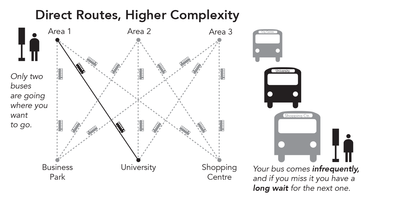
Direct Routes, Higher Complexity
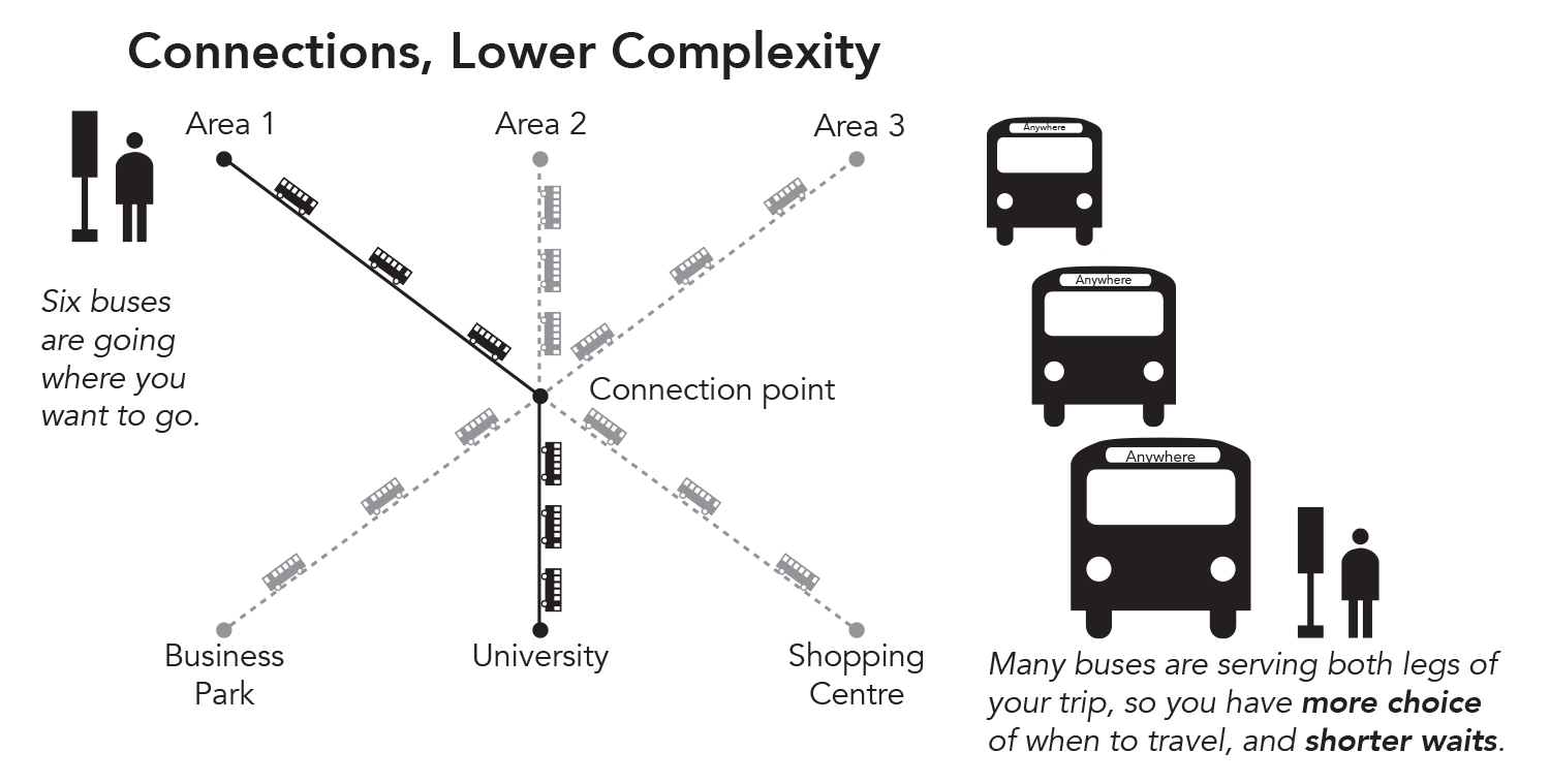
Connections, Lower Complexity


Increase Access by Offering Better Frequency
A public transport network should be greater than the sum of its parts. One bus route can take people to only certain places – but if it makes connections with many other routes and with trains, vastly more places become reachable.
A connected network is key to maximising transport access and thereby transport patronage. A connected network can be simpler, offering better frequencies and therefore shorter waits.
(Click images to enlarge.)
Direct Routes, Long Waits, Complexity
In this network, each route comes every 30 minutes. Using any route requires a long wait.

Interchange, Short Waits, Simplicity
In this network, the same number of buses can connect the same places with routes coming every 10 minutes. Some trips require interchange, but waits are much shorter.
But a connected network relies on interchange, and interchange can present a barrier if:
- An extra fare is charged to change buses.
- Waiting at the interchange point is uncomfortable.
- Bus arrival times are not reliable.
- Finding the correct bus stop or bus is difficult, or requires a long walk.
As part of BusConnects Galway:
- There will soon be no additional fare to interchange, neither among buses nor between buses and trains.
- Bus stops and shelters where many people wait will be made more comfortable.
- Bus reliability will be improved, thanks to Cross-City Link and other BusConnects measures.
- Walks to interchange can be made shorter.
All of these changes make it possible to design the bus network for faster journeys, greater access and greater patronage, if more interchange is tolerable. How could it be that designing a network for interchange could get people where they're going sooner? Watch the video to learn how.
Image gallery contents:
Density
Walkability
Linearity
Proximity
Mix of uses


Where to Provide Frequent Service
One of the most powerful ways to increase access across a public transport network is to shorten waits by improving frequency. More frequent service:
- Reduces waiting time (and thus overall travel time).
- Lets you travel whenever you want.
- Improves reliability, because if you miss your bus another one is coming soon.
- Makes interchange (between two frequent services) fast and reliable.
In the future the Galway bus network will offer real-time arrival information. But even with this technology, routes that are infrequent will still require people to wait. Someone who isn’t pressed for time, or can time their trip to the bus schedule, may not mind using an infrequent route. But most people don’t have that flexibility when going to work, school or an appointment, and a worse frequency often means arriving someplace earlier than they’d like to.
When frequency is improved in places with large numbers of people, jobs and other opportunities, that improves the population’s average access.
Better frequency increases potential for high patronage…but it isn’t enough to cause high patronage. Development patterns, land use and street design have a huge impact on how many people public transport can reach efficiently, and therefore on where frequent service can be provided.
Recognising areas with high patronage potential
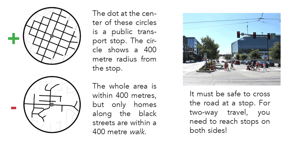
Density
A place that is dense with residents, employees, shoppers, students, and visitors has more potential public transport users near each bus stop.
(Click images to enlarge.)
Walkability
To use a bus route, people need to be able to get to the stop, and the vast majority of passengers start their trip by walking.
The street network, footpaths and crossings around a bus stop affect how many people are willing and able to walk to it.
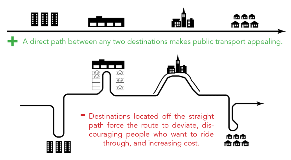
Linearity
Exactly where buildings are built determines how linear and efficient public transport routes can be.
When dense developments are far from main roads, or buildings are set at the ends of cul-de-sacs, bus routes must be meander to get close to people. This makes passengers’ journeys longer, and the route costs more to operate.

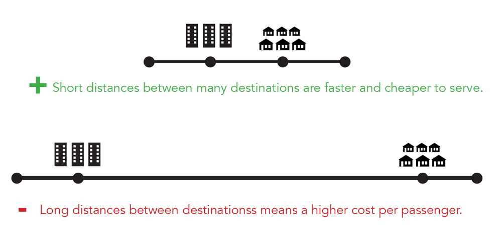
Proximity
Distance is a major contributor to the cost of providing bus routes. The greater the distance, the fewer people can be served within any particular operating budget.
Places that have continuous density and activities along a road are more efficient to serve and can be served with more frequent routes.

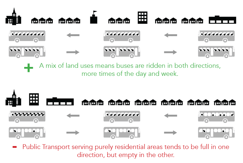
Mix of Uses
The mix of uses along a road affects how efficiently public transport can serve people. In areas with jobs, shops and housing, people are riding in all directions at all times of day and week. This means that vehicles can be full most of the time that they are out providing service.
Transport in purely residential or job areas tends to be used mostly in one direction – for example, in the mornings buses would be full traveling away from the residences, towards jobs, and mostly empty heading back the other direction. This means the cost of the service is divided over fewer passengers.
Benefits of the Draft New Network
- Bus services would increase by nearly 50%.
- Within 30 minutes or less, the average resident could access 38% more jobs on weekdays ... and 43% more jobs on Saturdays.
- Many more residents and jobs would be five minutes’ walk or less from frequent service, on weekdays and weekends.
- A 24-hour route would connect the City Centre, Doughiska, Parkmore, Knocknacarra, universities and hospitals.
How would the network be different?
- Shorter waits and easier interchange, thanks to better frequencies.
- Straighter and faster journeys.
- More routes operating at evenings and weekends.
- Better frequencies at evenings and weekends.
- Some changes to cross-town routes in terms of which areas are directly connected to one another.
- Service in new areas such as Upper Ballymoneen Road, Roscam, Oranmore and others.
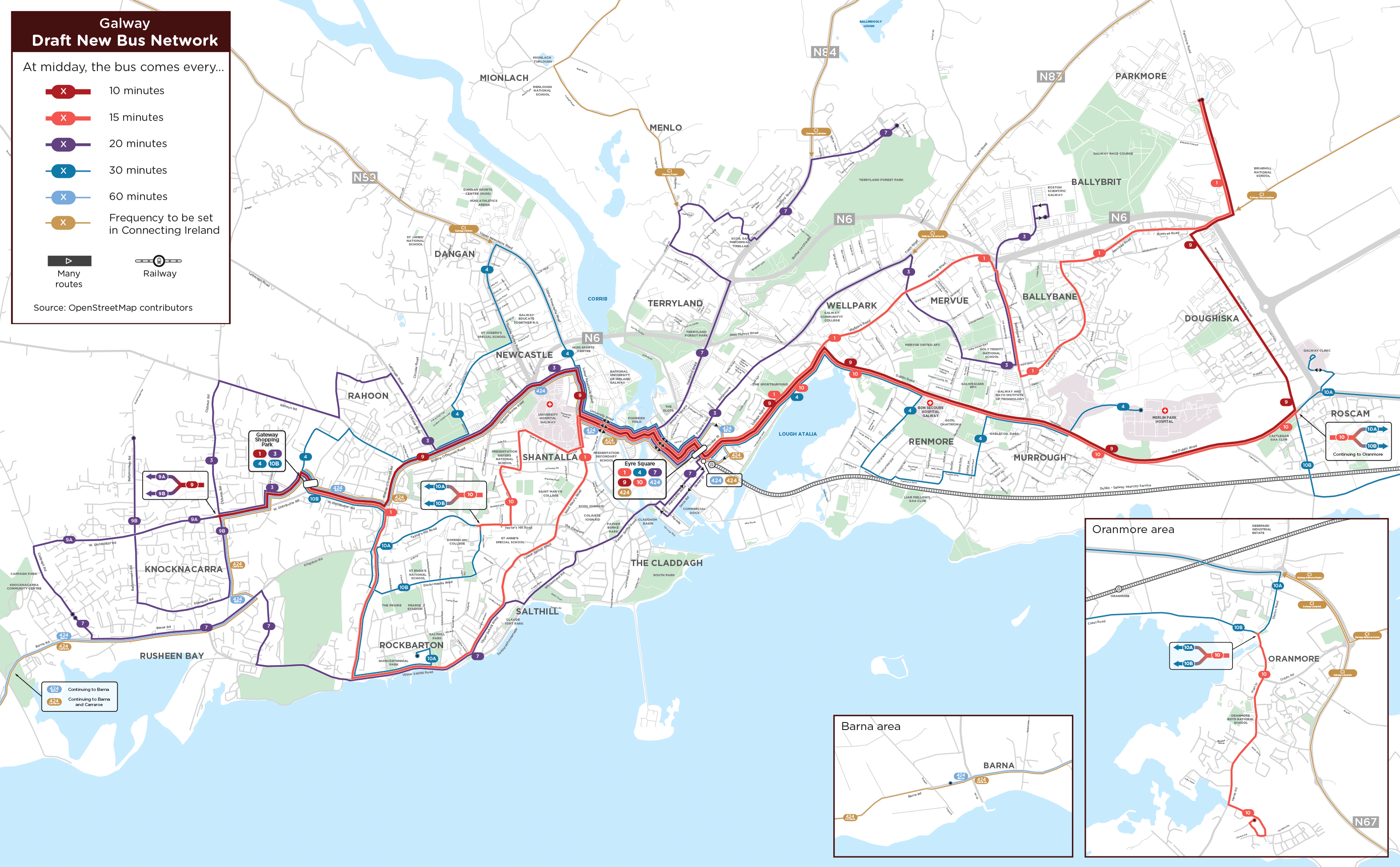
Network Map
Instructions: You can use the map below to compare the locations and frequency of existing and proposed routes and see how access to jobs would change with the New Network. Search by address, click, drag, and zoom to find specific locations. After you click a location, click the buttons on the map toolbar to show and hide information about how the new network would serve that area.
Can't see the map? Try opening in a new window.
Image gallery contents:
Draft New Bus Network
Draft New Bus Network


Timeline
Public input in response to the Draft will inform the Final New Network. It will also inform parallel BusConnects programmes and local plans, such as the development of bus corridors and cycle lanes, and the update of the Galway Metropolitan Area Transport Study.
The Final New Network will be published later this year, and changes to routes are expected to begin in 2025.
Stay involved
If you wish to be kept apprised of the progress of this study and opportunities for public comment, send an email to galwaynetwork@busconnects.ie and you will be added to the announcement list.
For more information
Visit busconnects.ie/galway